

Chandler Williams1, Gregory Reichberg1, Giacomo Bruni1, Ritisha Das2
1 Peace Research Institute Oslo (PRIO)
2 Massachusetts Institute of Technology (MIT)
We come away from the Satellites for Peace conference humbled. Humbled by the work being done by so many of the people in the room, work that continues while the world faces more armed conflicts than at any time since 1946 and while funding for peace-supporting work is being cut. While the program was built around improving access to high-resolution optical imagery, over two days, participants widened that discussion considerably. They showed the exceptional work this community already does in support of peace, using many types of sensors across a wide range of resolutions, often with minimal funding and while navigating further cuts and uncertainties that are straining the wider humanitarian sector. This statement reflects the authors’ understanding of the discussions and does not imply endorsement by conference participants or their organizations. It shares some of what was learned and how we may continue to support this work at a time of political and financial pressure.
The conference
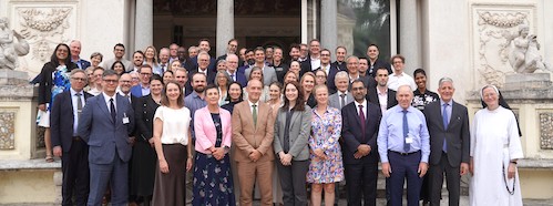
On 24–25 June 2026, the Pontifical Academy of Social Sciences (PASS) convened a conference at Casina Pio IV in Vatican City to examine how satellite-based remote sensing can support humanitarian, human-rights and peacebuilding work in conflict-affected settings. The conference was co-organized with two research organizations, the Peace Research Institute Oslo (PRIO) and the Institute for Economics and Peace (IEP); two United Nations entities, the United Nations Development Programme (UNDP) and the United Nations Satellite Centre (UNOSAT); and Kongsberg Satellite Services (KSAT), a provider of ground-network and earth-observation services. Participants came from UN entities, humanitarian, development, and human-rights organizations, peace and conflict research, space agencies, satellite operators and analytics providers, gov
... Read allChandler Williams1, Gregory Reichberg1, Giacomo Bruni1, Ritisha Das2
1 Peace Research Institute Oslo (PRIO)
2 Massachusetts Institute of Technology (MIT)
We come away from the Satellites for Peace conference humbled. Humbled by the work being done by so many of the people in the room, work that continues while the world faces more armed conflicts than at any time since 1946 and while funding for peace-supporting work is being cut. While the program was built around improving access to high-resolution optical imagery, over two days, participants widened that discussion considerably. They showed the exceptional work this community already does in support of peace, using many types of sensors across a wide range of resolutions, often with minimal funding and while navigating further cuts and uncertainties that are straining the wider humanitarian sector. This statement reflects the authors’ understanding of the discussions and does not imply endorsement by conference participants or their organizations. It shares some of what was learned and how we may continue to support this work at a time of political and financial pressure.
The conference
On 24–25 June 2026, the Pontifical Academy of Social Sciences (PASS) convened a conference at Casina Pio IV in Vatican City to examine how satellite-based remote sensing can support humanitarian, human-rights and peacebuilding work in conflict-affected settings. The conference was co-organized with two research organizations, the Peace Research Institute Oslo (PRIO) and the Institute for Economics and Peace (IEP); two United Nations entities, the United Nations Development Programme (UNDP) and the United Nations Satellite Centre (UNOSAT); and Kongsberg Satellite Services (KSAT), a provider of ground-network and earth-observation services. Participants came from UN entities, humanitarian, development, and human-rights organizations, peace and conflict research, space agencies, satellite operators and analytics providers, governments, universities, foundations and faith communities.
The conference was designed to examine current opportunities and challenges vis-à-vis access to satellite data and the use of satellite-derived evidence for peace-support activities. Humanitarian, peacebuilding, and development organizations employ geospatial evidence to understand emerging risks, assess displacement and civilian harm, monitor ceasefires, document violations, plan recovery and track the conditions that sustain peace.
What we mean by peace
Catholic social teaching holds that peace “is not merely the absence of war” but “an enterprise of justice” (Gaudium et Spes, 78). Peace research, following Johan Galtung, distinguishes “negative peace,” the absence of violence, from “positive peace,” which the IEP describes as “the attitudes, institutions and structures that create and sustain peaceful societies.” Drawing on both, we understand peace-supporting uses of satellite data as uses that serve people affected by armed conflict across the full continuum from prevention to recovery: anticipating and preventing violence and atrocities; protecting civilians and civilian objects, including cultural and religious sites, as international humanitarian law requires; enabling humanitarian assistance; documenting violations and supporting accountability; and supporting recovery and development that allow peace to last. Sustainable development is itself essential to lasting peace, since poverty, hunger, environmental degradation and displacement can compound the drivers of conflict. Participants reminded us that peace is never politically neutral, and that deciding what counts as a peace-supporting use is itself a question of governance.
A field under pressure, and its invaluable work
The need for this work is growing. PRIO recorded 65 state-based armed conflicts in 35 countries in 2025, the most since its records begin in 1946. In the same year, the UN-coordinated humanitarian appeal received $12 billion, its lowest level in a decade. Many entities at the conference spoke about what this means in practice: short funding cycles; too few analysts for the data available; trained staff moving on before their knowledge can be passed on; reliance on a single donor or on the goodwill of partners; early-career researchers losing the funding that brings them into the field; and long-standing programs whose future is uncertain. Much of the work described below continues despite these challenges, due to the dedication of the individuals doing it. This work deserves greater financial and political support. Any reduction in these capacities risks leaving the world less able to anticipate, document and respond to violence, and therefore less stable and less peaceful.
The conference did not need to establish whether satellite evidence can serve peace. Participants showed that it already does, often in very difficult conditions. Among the many examples discussed, UNOOSA supports the Committee on the Peaceful Uses of Outer Space (COPUOS) in its work to preserve the peaceful use of outer space, and also conducts global training programs on the use of satellite imagery. UNOSAT reported supporting 225 operations in around 80 countries between 2022 and 2025. Human Rights Watch described geospatial analysis as informing much of its reporting; in Mariupol, unable to enter the city, its researchers and partners counted new graves in the city’s cemeteries from satellite imagery to reach a conservative estimate of the dead. ICRC described using imagery to find safe exit routes and hospital access for colleagues in Gaza. A UNDP representative speaking from Gaza described how the agency combines high-resolution imagery with field verification to assess damage, plan temporary shelter and target water delivery; UNDP applies similar assessments in Ukraine to support local recovery.
Research groups contribute tools and methods that many practitioners draw on. The Conflict Ecology Lab at Oregon State University, working with partners in the Decentralized Damage Mapping Group, uses free and open synthetic aperture radar (SAR) data to track war damage in conflicts including Gaza, Lebanon, Iran, and Ukraine. Yale’s Humanitarian Research Lab combines very-high-resolution imagery with thermal data to warn of atrocities in Sudan and continues to document them. Other researchers use thermal detections to record the torching of villages that conflict event datasets often miss, and some are exploring how satellite-derived data can inform indicators of positive peace. Cultural heritage monitoring initiatives, such as HeritageWatch.AI, use satellite imagery and AI-powered change detection to follow damage and looting at archaeological and heritage sites in conflict-affected settings.
Much of this work relies on free and open data across a range of sensors and resolutions, including data from the EU/ESA Copernicus Sentinel missions and NASA/USGS Landsat, and has benefited from these programs’ long-standing commitment to open data and training. It is supplemented at times by high- and very-high-resolution imagery made available through commercial open-data, research and grant programs, or through direct purchase. Nonprofit efforts, such as CommonSpace, are working to make more high-resolution imagery available for humanitarian use. These are examples from the conference, not a full account of the much larger field of peace-supporting initiatives. In particular, they leave out much of the essential work being done by groups outside the North Atlantic and by communities affected by armed conflict. We hope to include these voices more fully, and to support their initiatives, in the time ahead.
Reflections from the discussions
While there were many important takeaways from the conference, we highlight the following:
Imagery does not speak for itself: Participants stressed that using imagery as evidence requires careful analysis, interpretation and verification, including, where possible, checking findings against field observations and reports from the ground. Access to imagery and access to evidence therefore face different obstacles. Across several discussions, the availability of skilled analysts emerged as a major constraint, followed by computing capacity, verification methods and the ability to move analysis into operational or political decision-making. Some practitioners described people as the largest part of their costs, followed by computing, and only then data. However, others stressed that access to imagery remains uneven and uncertain. End-users described delays in delivery, licenses that lapse or are withdrawn at critical moments, near-real-time needs met only after several days and forgotten emergencies that receive far less attention than others. Some organizations with excellent access to data struggle to pay for the people needed to use it; others have neither. The discussions therefore pointed to two related but distinct challenges: making data available and ensuring that organizations have the capacity to turn that data into reliable and actionable information.
Useful evidence spans sensors and resolutions: Participants emphasized that choosing the right sensor, spatial resolution, and revisit frequency depends on the task at hand. VHR optical imagery (<1 m resolution) matters when fine detail is needed, such as identifying individual structures, graves or vehicles, or helping verify what happened at a specific site. Free and open data support systematic monitoring across large areas and over time, with accessible archives that enable others to revisit and build on analyses. Some damage mapping across entire conflict zones is conducted with radar and optical imagery at moderate spatial resolutions (approximately 10–30 m) from missions such as Sentinel-1, Sentinel-2 and Landsat. Thermal detections from VIIRS and MODIS can flag possible fires and, alongside other evidence, help identify the burning of villages and fields. Participants highlighted the particular strength of integrating data from different sensors and resolutions over time, and of pairing these data with reports and open-source information.
AI-enabled analytical workflows still need human interpretation: Automated tools already give analysts a first pass over large volumes of imagery and could lower the barriers for organizations without specialist staff. AI could also help integrate data from different sensors, allowing analysts to draw on complementary sources of evidence. But models that perform well on technical benchmarks can fall short in real crises, especially where the field data needed to train and test them are scarce or withheld, and automation can reproduce existing blind spots rather than correct them. Participants called for ethical safeguards, clear accountability and shared guidelines to be developed now, before these tools become embedded in decisions that affect people’s lives, and for models built around specific tasks and validated against conditions on the ground. Participants highlighted the continuing importance of human verification.
Existing routes to data access are patchy and inconsistent at times: Several established programs support access to satellite data. Copernicus Sentinel and Landsat data are free and open. Some commercial providers, including Planet, offer free or discounted access through research and education programs, subject to eligibility and licensing conditions. Norway’s NICFI program has also supported access to high-resolution imagery of forest in the tropics. For natural disasters, the International Charter “Space and Major Disasters” provides imagery from participating space agencies and operators, though its mandate does not cover armed conflict. However, participants also described difficulties sustaining access, including instances of access being lost during a crisis, as well as limited funding for humanitarian work among some providers. Access arrangements also fit some needs poorly: they are largely built around imagery of larger areas on one or a few dates, whereas some analyses need very small areas, sometimes only a few hundred pixels, observed over long periods, which can be harder to obtain and can quickly exhaust standard quotas even when the total number of pixels observed across all dates is comparable. Discussions covered pooled or multi-agency procurement, including an inter-agency mechanism proposed by UNOOSA, as well as predictable and more flexible pricing, agreements made before crises, and funding for analysts and computing alongside imagery.
Better evidence does not by itself produce action: Yale’s Humanitarian Research Lab described issuing warnings about the risk of atrocities in El Fasher to national and multilateral bodies, and attributed the lack of an effective preventive response to insufficient political will. Participants also discussed operational difficulties in communicating and using information intended to protect civilians. They noted that institutional priorities and political interests can shape how evidence is received and acted upon. Trusted channels and clear mandates can help evidence reach decision-makers, but cannot substitute for the political will to act on it.
Civil-military cooperation brings opportunities and difficult questions: Perspectives from defense and security institutions contributed to the conference. A speaker from the Center for Naval Analyses (CNA) described how information on the civilian environment, such as the locations of hospitals, often fails to reach military decision-makers, and proposed a federated exchange among humanitarian actors, militaries and the UN to help prevent civilian harm. The Colombian Aerospace Force and the Norwegian Defence Research Establishment (FFI) presented national programs built on dual-use satellite capabilities. With defense budgets rising as peace-supporting funding shrinks, some saw “dual-use” and “triple-use” (commercial, defense and peace) approaches as a way for capabilities built for security to also serve civilian protection. Others cautioned that the principles of neutrality and independence guiding many humanitarian organizations can limit what they share with militaries, and that programs reliant on government funding risk being shaped by military priorities. Some framed the question as where coordination should end and independence begin, for example cooperating on data supply and civilian protection while keeping the tasking and use of humanitarian imagery separate. These questions remain open, and we see value in working through them with defense, humanitarian, peace and commercial actors alike.
Much already exists, and it is stronger when connected: Participants highlighted the breadth of existing initiatives and saw an opportunity to strengthen coherence and complementarity among them. Within the UN system, discussions are already under way on coordinating the acquisition and sharing of satellite imagery. Participants saw value in pooling demand, sharing imagery and ground-truth data, and agreeing on common standards, so that limited resources go further and work done once can serve many. They pointed to mechanisms that already work well, from UN-SPIDER to the Humanitarian OpenStreetMap Team and open academic datasets, and some stressed that any new coordination should build on these rather than run alongside them. Others noted that distinct mandates exist for good reason, and that greater coherence need not mean consolidation. Several felt that the greatest value may lie less in new structures than in stronger connections among those that already exist.
Our commitment and path forward
Participants came together in difficult times. As we heard throughout the conference, funding for humanitarian and peace-supporting work is being cut, and many of the organizations doing the work described here now compete for the same shrinking pool of resources. We are mindful that any new effort in this space should add to what the field has rather than draw from it, and should do no harm, both to the people and places being observed and to the organizations that sustain this important work.
Participants also pointed to where support could make a difference: predictable, long-term funding for analysts and computing as well as data; access agreed before crises rather than negotiated during them; shared ground truth and training data; pathways that bring students and early-career researchers into the field; and a stronger voice for affected communities, including in decisions about how they are observed.
In that spirit, we commit to exploring how best to support coordination among, and collaborative investment in, the people and efforts working in this domain, so that the individuals and organizations providing critical support to communities affected by armed conflict can continue and strengthen their work. We also hope to help widen the circle, so that new voices and contributions, including from affected communities, from groups outside the North Atlantic and from sectors not currently engaged, bring more hands, and more resources, to this work.
We came to the conference with the idea of establishing a Satellites for Peace Alliance. We heard clearly, at the conference and in the conversations since, that such an alliance could serve this community only if it is built carefully and together, and we are grateful for how candid participants were about what it should and should not be. It should not duplicate mechanisms that already work or draw on the limited funding the field depends on, nor should it focus solely on widening access to data, when supporting the community of analysts who derive actionable evidence from data is also an imperative. It should connect and strengthen what already exists (including the networks and forums through which many in this community already meet); rest on clear ethical principles from the outset; give affected communities a real say; remain open and transparent, free of any single national or commercial agenda; and start small, proving its value through practical work. We take these as starting points for what follows.
The conference showed the value of bringing people together across sectors, and we hope Satellites for Peace can remain a place where every sector can contribute and engage, without asking more of organizations already stretched thin. We continue to see a need for such an alliance and are now working to identify mechanisms that can support its development. We will continue the conversations begun in Vatican City through consultations with interested partners on what form the alliance should take, which practical needs it should address, and how it can best support existing efforts. We warmly invite all who share these aims, whether or not they were in the room, to take part.
We will carry what we heard to governments, foundations and other stakeholders, and keep this conversation open to all who do this work. We thank everyone who contributed, at the conference and in the conversations since, and above all this community, which for years has kept watch on behalf of people the world too often overlooks. We will lend our support however and wherever we can.
Closing
Space, as the Catholic Church has repeatedly affirmed, should be an arena of collaborative activity that benefits all humankind. The work of putting satellite data and its derived evidence at the service of peace began long before this conference, carried by the people who gathered in Vatican City and by many others who could not attend. We commit to supporting that work as one concrete expression of this principle, alongside the community that built it.
Read Less